Hurricane Ian Nears Category 5 Storm Status Before Florida Landfall
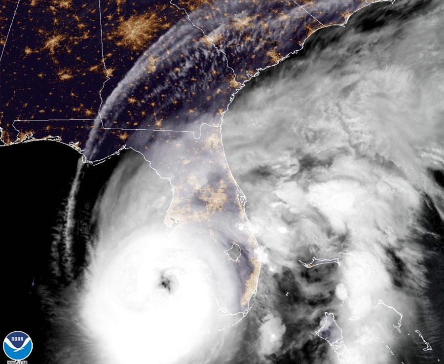
Prior to making landfall in Florida, Hurricane Ian has strengthened into an extremely dangerous category 4 storm, nearing category 5 status with maximum sustained winds of 155 mph. Walt Disney World is now under a hurricane warning, as the system is expected to approach Orlando tonight. In this, we’ll update you on the Ian’s status with advisories from the National Hurricane Center, with graphics from the NHC, NOAA, NWS, and more.
Walt Disney World and other Central Florida attractions have announced closures since our latest update. All 4 Theme Parks at Walt Disney World Will Close Due to Hurricane Ian, as will Universal Orlando, SeaWorld, Busch Gardens, LEGOLAND, and more. That was updated earlier this morning, and contains new information and details as of September 28.
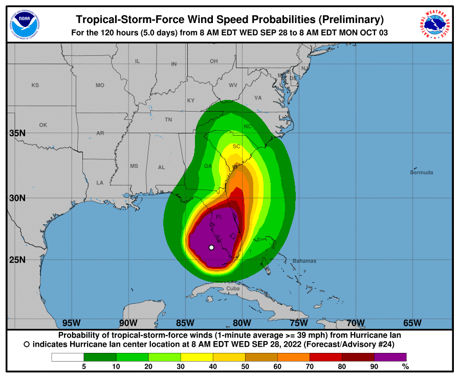
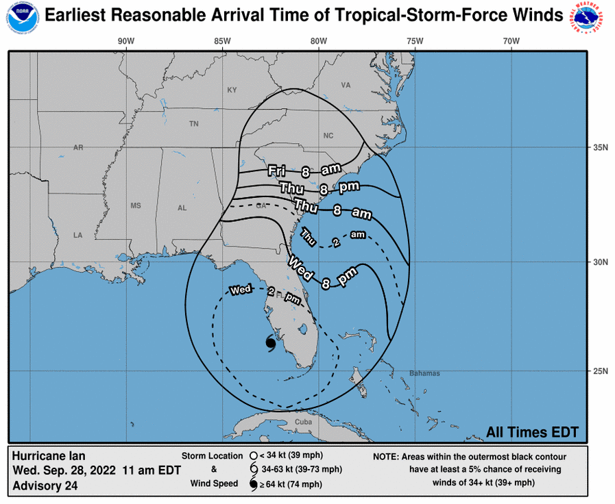
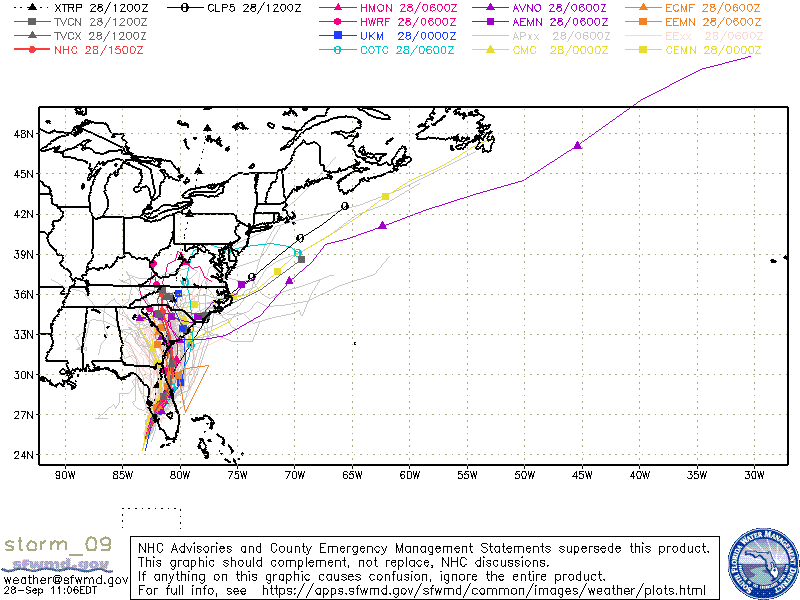
The National Hurricane Center updates its Hurricane Ian Advisory every few hours, at which point it shifts the ‘cone of uncertainty’ representing the range of possibilities for the storm’s center that extends up to five days into the future. The cone of uncertainty predicts the hurricane’s path, but even outside of the cone, ferocious winds, storm surge, heavy rains, and other intense weather can be felt. Let’s start with the latest of these advisories, issued at 11 am by the NHC (plus accompanying new graphics):
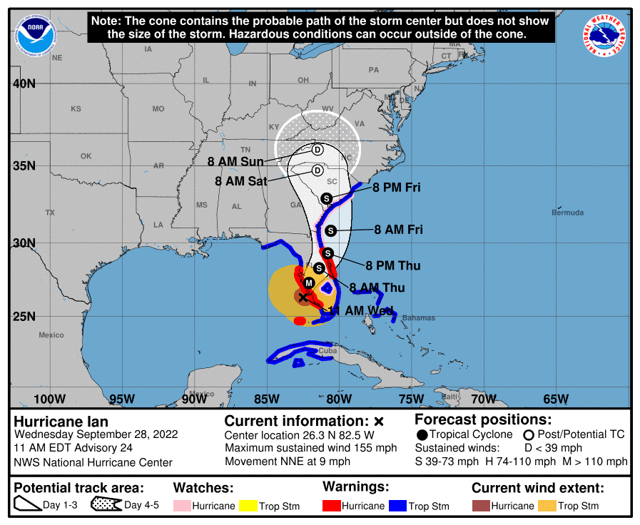
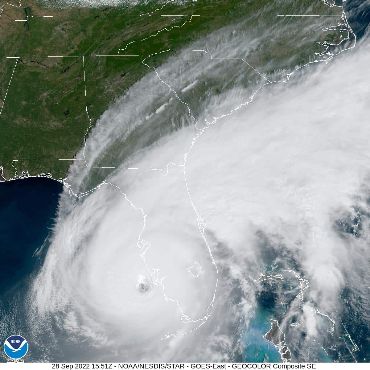
In the 11 am update, the National Hurricane Center reported that the center of Hurricane Ian was approximately 45 miles west-northwest of Naples, 50 miles south-southwest of Punta Gorda, and 165 miles south-southwest of Orlando. The system is moving north-northeast at 9 mph and remains a Category 4 system.
Data from an Air Force Reserve and NOAA Hurricane Hunter data was “absolutely critical” in diagnosing the rapid intensification of Hurricane Ian, despite both planes undergoing multiple eyewall penetrations experiencing severe turbulence. That data supported an intensity of about 135 kt a few hours ago.
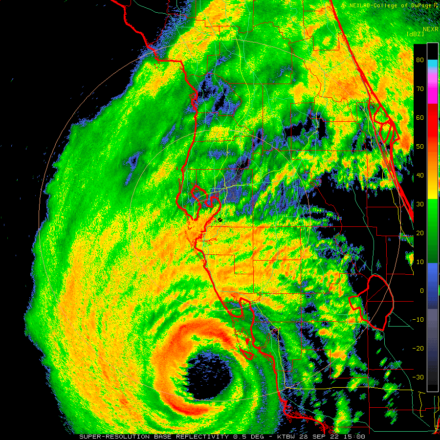
Since that time, high-resolution Tampa Doppler radar data has been sampling the eyewall near 10,000 ft with winds up to 155 kt, indicating that Ian is on the threshold of Category 5 status. The maximum winds are set to 135 kt on this advisory.
According to the 11 am NHC update, Hurricane Ian is expected to make landfall in southwestern Florida in the next few hours as a catastrophic hurricane. No changes were made to the track forecast near Florida, except to be faster to come into line with the latest consensus aids.
One important change is that Ian is likely to remain more intact as it crosses the Florida peninsula (due to both its stronger initial wind speed and its faster forecast forward speed), and this now increases the threat of hurricane-force winds on the east coast of Florida.
This necessitates the issuance of a Hurricane Warning on the east coast of central Florida. While significant re-strengthening of Ian might not occur over the Atlantic Ocean, model guidance has been catching up with a trough interaction from a shortwave over the southern United States, and are stronger than yesterday on Ian’s intensity.
Thus, a Hurricane Watch has been issued from northeastern Florida northward up the coast through most of coastal South Carolina. The new intensity forecast for Hurricane Ian is raised from the previous one.
Per an earlier full update from the National Hurricane Center on September 28, fluctuations in intensity are possible before the center reaches the coast later today, but Hurricane Ian is expected to reach the coast of Florida as an “extremely dangerous” category 4 hurricane according to the NHC. However, weakening is expected as Ian moves over the Florida peninsula.
Ian has shifted a little to the left this morning, but the longer-term motion remains north-northeastward, as the system continues on a path that is expected to take it just south of Walt Disney World property.
The hurricane should continue moving north-northeastward through Thursday between the western side of a subtropical ridge and a broad trough over the eastern United States. This motion is expected to bring the center of Ian onshore along the west coast of Florida later today, and over central Florida tonight and Thursday.
After that, Ian is expected to turn northward along coast of northeastern Florida and Georgia Thursday night and Friday.
According to the National Hurricane Center, here are the Key Messages for Florida (all direct quotes):
1. Catastrophic storm surge inundation of 12 to 18 feet above ground level along with destructive waves are expected somewhere along the southwest Florida coastline from Englewood to Bonita Beach, including Charlotte Harbor. Residents in these areas should urgently follow any evacuation orders in effect.
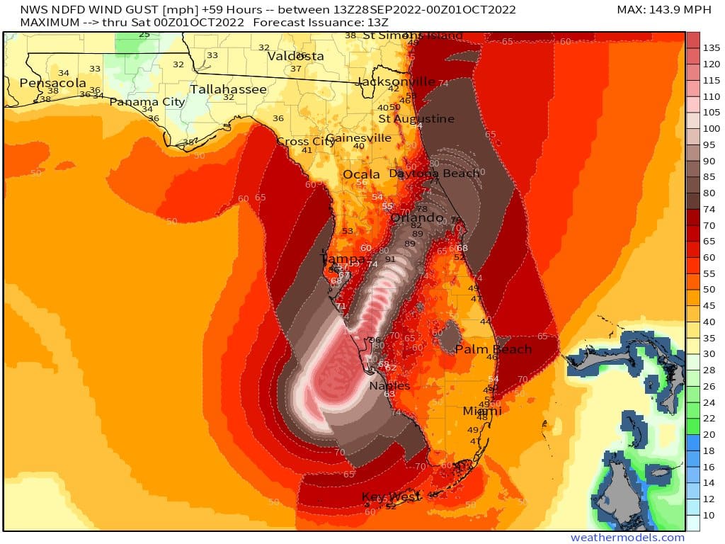
2. Catastrophic wind damage is beginning along the southwestern coast of Florida today near the landfall location. Hurricane-force winds are expected to extend well inland along near the core of Ian. Preparations to protect life and property should be urgently rushed to completion.
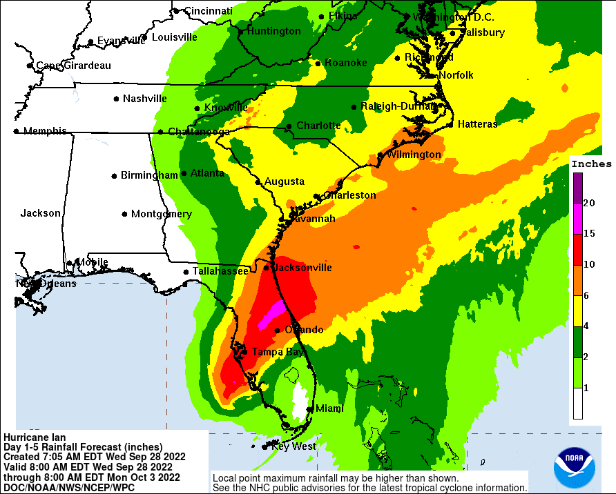
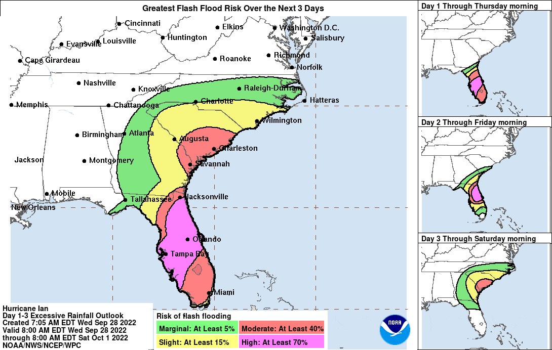
3. Heavy rainfall will spread across the Florida peninsula through Thursday and reach portions of the Southeast U.S. later this week and this weekend. Widespread, life-threatening catastrophic flooding is expected across portions of central Florida with considerable flooding in southern Florida, northern Florida, southeastern Georgia and coastal South Carolina. Widespread, prolonged major and record river flooding is expected across central Florida.
4. Hurricane conditions are expected along the east-central Florida coast overnight, where a Hurricane Warning has been issued. Hurricane conditions are possible from northeastern Florida to portions of South Carolina on Thursday and Friday, and a Hurricane Watch has been issued for that area.
The aforementioned Hurricane Warning includes Orange, Osceola, and other inland Central Florida counties. These remain under Hurricane Warnings as Ian could result in catastrophic flooding and hurricane-force gusts to the region.
Central Florida is now also under a tornado watch, as the outer bands of Hurricane Ian have produced several damaging twisters. Consequently, multiple tornado warnings have been issued according to the National Weather Service–these include Osceola and Orange Counties, among many others.
Florida Governor Ron DeSantis held an early morning press conference on Wednesday from the state Emergency Operations Center in Tallahassee during which he addressed the strengthening and arrival of Hurricane Ian. “The strengthening of this over the last night has been really, really significant,” DeSantis said. “It could make landfall as a Category 5.”
“This is a very powerful major hurricane that’s going to have major impacts, both on southwest Florida, but then as it continues to work through the state,” DeSantis continued. Hurricane Ian will have “major, major impacts in terms of wind, rain, [and] flooding. This is going to be a nasty, nasty…two days.”
“It’s time to hunker down and prepare for the storm. This is a powerful storm that should be treated like you would treat it if a tornado was approaching your home,” DeSantis said. He also indicated that there are hundreds of shelters open for those who need somewhere safe to stay during Hurricane Ian.
“There’s already 40,000 power outages reported, but outside of southwest Florida, crews have been responding to those power outages,” DeSantis said. Previously, he has said that “tens of thousands” of people are on standby to ensure power is restored as promptly as possible and that all of the state’s long-term care facilities in the state have an active generator on site with the threat of major power outages this week.
Over 5,000 National Guardsmen from Florida plus several thousand more from neighboring states have been activated, along with search and rescue teams. Residents are advised to avoid trying to drive down flooded roads after Hurricane Ian passes.
“If there are flash flood warnings, remember it is never safe to drive through flooded areas,” said Kevin Guthrie, Director of the Florida Division of Emergency Management. Guthrie added that emergency managers in Florida are preparing for Hurricane Ian to strengthen to a Category 5 system.
Guthrie also addressed comparisons to Charley, which were drawn for a second consecutive day during the Emergency Operations Center news briefing. “It does have a Charley-esque feel. One of the things that’s a little different with Charley is [Hurricane Ian] may go through Central Florida with less intensity than Charley.”
“The big difference is it will have less intensity once it hits Central Florida,” Guthrie said. Hurricane Ian “shouldn’t be nearly as catastrophic as the winds on Charley,” Guthrie added. The National Weather Service in Melbourne is forecasting hurricane-force winds gusts of up to 90 mph in Orlando by early Thursday.
Hurricane Ian’s projected path is strikingly similar to that of Charley, which hit Florida as a major Category 4 hurricane and arrived in Central Florida as a Category 1 system with sustained winds of 80 mph and wind gusts up to 110 mph. While Hurricane Ian is not forecast to be quite that intense upon arrival in the Walt Disney World area, it doesn’t need to be to cause considerable damage. Its larger size and current conditions–due to prior precipitation–could result in extensive damage and power outages throughout the Orlando area.
If you are anywhere in Central Florida, stay safe. If you’re at Walt Disney World, remember to be kind and extend some grace to Cast Members and other guests. Many people staying at the resorts are seeking shelter from coastal areas where Hurricane Ian is making landfall, and are likely on edge about their homes, friends and family.
Some Cast Members are Florida transplants and, given the amount of time that has passed since the last major system, this is probably the first major hurricane they’re experiencing since moving to Florida. Many of those Cast Members are also College Program or International Program participants, living alone away from home for the first time in their lives. I cannot imagine how terrifying this is for them and their families. In short, everyone is doing the best they can, which is worth keeping in mind when interacting with others–courtesy and kindness go a long way. Here’s hoping this passes quickly and with minimal damage and harm, and Walt Disney World can resume normal operations on September 30, 2022. We’ll keep you posted either way!
Planning a Walt Disney World trip? Learn about hotels on our Walt Disney World Hotels Reviews page. For where to eat, read our Walt Disney World Restaurant Reviews. To save money on tickets or determine which type to buy, read our Tips for Saving Money on Walt Disney World Tickets post. Our What to Pack for Disney Trips post takes a unique look at clever items to take. For what to do and when to do it, our Walt Disney World Ride Guides will help. For comprehensive advice, the best place to start is our Walt Disney World Trip Planning Guide for everything you need to know!
YOUR THOUGHTS
Thoughts on the latest National Hurricane Center forecast for Hurricane Ian showing the storm near Category 5 status? Concerned about the consensus showing the system moving directly through Walt Disney World? Are you currently in Central Florida? Have you visited during past hurricanes? Any additional info, thoughts, or first-hand experiences to share about riding out a hurricane at Walt Disney World? Any questions we can help you answer? Hearing your feedback–even when you disagree with us–is both interesting to us and helpful to other readers, so please share your thoughts below in the comments!
Sorry folks but the grown up thing to do is cancel any trips to happy land for the next few months. Any/all the resources needed to entertain you will be desperately needed elsewhere — food water housing — including the employees who’s time could be better spent rebuilding their community and not dancing around trying to make little Susie laugh. They don’t need you down there unless you are wearing work boots.
Also, the good news for Orlando and WDW, is that the slow speed of the storm means it is shedding wind, down to 90 mph for the 11pm EDT update, and the track looks to pass further south than it looked like even this evening. This means that WDW, especially the Magic Kingdom. might miss sustained hurricane force winds. or have a reduced exposure to such winds. However, don’t get caught off guard, the track could still wobble closer, before the danger is done.
Stay safe!
One (more) thing to remember: All storms are unique. A smaller storm with higher windspeed that is fast moving might cause less damage than a slower moving storm with lower windspeeds. Although storm surge is not an issue for WDW, I will never forget evacuating from Hurricane Katrina. listening to the Mississippi Emergency Broadcasting System, including speaking to people who were going to ride out on the bluffs of Bay St, Louis. Katrina was decreasing in windspeed, and legendary Cat 5 Hurricane Camille hadn’t reached where they were. Katrina went ashore as a Category 3, but was so massive, its storm surge shattered Camille’s substantial record overtopping the bluffs of Bay St. Louis and wiping out every home on them.
Be careful of trees with the ground being super saturated, they can still fall after the storm passes.
Stay away from powerlines.
Be SUPER careful if you’re using a portable generator; there have been recent hurricanes where more people have died from fires and carbon monoxide poisoning than from the storm itself.
As always, stay safe!
Thumbs up, Tom.
My granddaughter, from the West coast, is in Orlando for the Disney College program and I am trying not to worry but it is hard to do. She just turned 21 and that still seems young without family and close friends nearby. Would appreciate prayers and good thoughts for minimal damage in Orlando for everyone.
I once heard a rumor that Cinderella’s Castle can be taken apart when a hurricane comes. Is there any truth to this at all? There’s a restaurant in that building, so I would doubt you could take apart the whole thing.
This is an urban legend in the sense that it’s never happened at Walt Disney World for a hurricane.
However, it is theoretically possible (to at least some extent), which might be how the ‘rumor’ got started? Here’s our post and photos from when Tokyo Disneyland removed the top of Cinderella Castle: https://www.disneytouristblog.com/urban-legend-come-true-cinderella-castles-top-spire-removed/
Tom and Sarah, Sending prayers for your safety and the safety of all of the Cast Members at the Disney facilities. Everyone be safe.
Thanks for the kind words (and others in the comments who have expressed similar sentiment).
However, we’ve actually relocated back to California. Obviously not relevant here, but it has been quite the process, and you probably haven’t noticed because we’ve basically been splitting time between the coasts, bouncing back and forth a lot for a number of reasons. We were on the fence about heading out again for EPCOT’s 40th, but nixed that earlier this week when the model consensus became clear that this was heading for Central Florida. We rode out one hurricane as tourists and experienced others (albeit nothing like this) as locals, and I cannot say it’s something I’ll miss. We feel for everyone there–especially all of the recent transplants who are undoubtedly terrified and away from family and friends.
Tom, that’s interesting. So if you live in California, how do you manage to go to Florida so often? How long do you stay? Just out of curiosity not judgement ☺️
There is no ‘average’ at this point, since it’s a relatively recent development and we’ve been going back and forth in part for non-WDW reasons.
With that said, this isn’t a totally new arrangement. We previously lived in California and ‘commuted’ to WDW about once per month. (To that point, we never intended to live in Florida for so long–it was “temporary” at first and extended multiple times.) My expectation is something similar this time–a visit once every few weeks for 3-7 days at a time, depending upon the circumstances.
Stay safe, Tom and Sarah!
We’re just outside of Tampa, riding it out. This is our first hurricane experience. My husband works in Tampa and his work sent out a mass text saying “be ready to return to work tomorrow”.
Tom–
With what you’ve seen from past weather events, when would you guess that WDW will be back up and running..barring any major damage. Again, great work, and prayers for all those in the middle of this storm.
Whenever the parks do reopen, don’t be surprised if certain attractions don’t reopen right away. Anything with a lot of trees is an obvious candidate. If I recall correctly, it took Jungle Cruise a day or two after Irma to reopen. Might be a similar story with trails and attractions in Animal Kingdom.
Outside the parks, there might be resorts that are out of commission entirely or have areas closed off due to downed trees.
We arrived yesterday at OKW and was supposed to go to AK Jambo on Thursday. But WDW sent an email saying no movement between resorts after 3pm today through Friday. So OKW staff were wonderful and arranged for us to stay an extra night here. All I can say is patience, gratitude, and smiles are what all CMs are exhibiting and we are being extra grateful to them for their hard work. They must be worried about their own families/homes but they have been wonderful!
TY for these articles! Stay safe!
Thanks for the updates. We leave on Friday for Disney and Universal. Waiting patiently to see what the damage and power issues will be. Hoping we are able to continue our plans for the week, but staying open minded as well.
Sending you and Sarah my best wishes that come through this storm safe and sound. All the Disney CM family will be in my thoughts over the next few days.
Sending you and Sarah (and everyone else in the path) well wishes. Stay safe, and dry.
If you’re at Walt Disney World, remember to be kind and extend some grace to Cast Members and other guests. Many people staying at the resorts are seeking shelter from coastal areas where Hurricane Ian is making landfall, and are likely on edge about their homes, friends and family.
Some Cast Members are Florida transplants and, given the amount of time that has passed since the last major system, this is probably the first major hurricane since living in Florida. Many of those Cast Members are also College Program or International Program participants, living alone away from home for the first time in their lives. I cannot imagine how terrifying this is for them and their families.
This is a main reason why you are my favorite Disney blogger. Wishing safety, kindness, and peace to you and Sarah.
Perfectly said, Lori!
This is really good info, Tom. Not for the first time, I’m impressed by your knowledge and understanding of non-Disney issues, in this case weather! Thank you. I’m hoping everyone stays as safe as possible in WDW and FL.
Thanks, but I will readily admit that I do NOT have knowledge and understanding of weather. You could say that I’m “good” at reading government agency updates, watching press conferences, and condensing/editing what I hear or read for clarity, while removing jargon.
I did the same thing for COVID and actually did learn a lot, but (thankfully) I have far less experience doing this and haven’t retained much of what I’ve read/heard.
Another 2 years before Tron opens.
lol I was thinking the same things